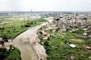
This project consists of 2 stakeholder workshops and 6 design charrettes which are held in a half a year’s time. The objective of the design charrettes is to develop, together with all stakeholders and communities, a strategic management framework for the entire catchment area of the Msimbazi River basin as well as a detailed plan for the lower part of the catchment. Charrettes (as means of participatory design process) are particularly suitable to address complex multi-facetted and interrelated social, technical and environmental issues. The Msimbazi River basin, covering a large part of Dar es Salaam’s urban area, is characterised by extreme high (informal) urbanisation rates, crossing of major infrastructures, a mosaic of different urban land uses and a whole range of environmental and sanitation issues. One of the main issues is the increasing severity and frequency of flash floods affecting the area.
CDR and partners carried out the following tasks: Charrette facilitation, Presentations, GIS, spatial analysis, mapping, bridging spatial, technical and social issues and integrate them into integral plan, river engineering, hydraulic modelling support, set-up of spatial design alternatives, conceptual design of hydraulic mitigation measures.
Site visit & drone images Dar es Salaam


